Mountain Huts
Mountain huts are both the destination of hikes and the starting point of alpine tours. If you want to stay there, we urgently recommend to book in advance, because especially in the high season, the seats are quickly occupied. Here are some to choose from:
|
|
|
Turtmannhütte, 2’519 m above sea level Telephone +41 27 932.14.55 by car via Turtmann, Oberems to the end of the Turtmann valley Ascent about 2 hours
|
|
|
| Schönbielhütte, 2’694 m above sea level Telephone +41 27 967.13.54 Ascent from Zermatt, walking time approx. 4 hours, When ascending, always the Matterhorn in mind |
|
|
| Täschhütte, 2’701 m.ü.M. Telephone +41 27 967.39.13 from Täsch by car to Ottavan, Ascent about 1.5 hours Gorgeous alpine flora (Edelweiss) |
|
|
|
Weissmies Hut, 2,726 m above sea level.
Telephone +41 27 957.25.54 (Starting point for via ferrata Jägihorn) with the mountain railway Saas-Grund to Kreuzboden, from there about 1 hour on foot or from Saas-Grund directly with a long hut rise of almost 4 hours |
Our first "four-thousanders"
| Even if we only recommend “lighter” four-thousanders, you should definitely bring enough mountain experience. In case of doubt we will gladly give you addresses of suitable mountain guides. |
|
|
|
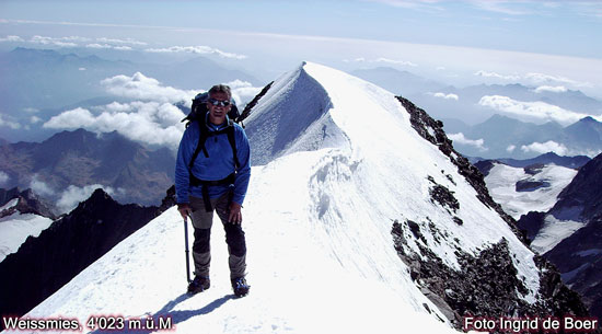
Weissmies, 4,023 m above sea level.
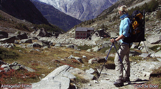
1. by car via Visp to Saas-Almagell in the Saas Valley (52 km / 1.5 hours) from Almagell on foot in about 2 1/2 hours to Almagellerhütte (2,894 m above sea level) From there climb to Weissmies summit in about 4 hours 2. by car via Visp to Saas-Grund in the Saas Valley (48 km / 1 h 20 min) from Saas Grund by train to Hohsaas (3,200 m above sea level), From there climb to the summit of Weissmies in about 4 hours |
|
|
|
Allalin, 4,027 meters above sea level
by car via Visp to the Saas Valley to Saas-Fee (50 km / 1.5 hours) from Saas Fee by train to Mittelallalin (3’454 m above sea level), from there climb to the summit in about 3 hours |
|
|
|
Bishorn, 4,153 meters above sea level.
by car to Val d’Anniviers to Zinal (33 km / 45 min), on foot in about 4 hours to Tracuithütte (3’260 m above sea level), From there climb to Bishorn in about 2 1/2 hours |
|
|
|
Breithorn, 4,164 meters above sea level.
by car via Visp to Täsch (55 km / 1.5 hours) in the Mattertal, with the shuttle train to Zermatt, from Zermatt by mountain railway to Klein Matterhorn (3,818 m above sea level), from there climb to the summit of Breithorn in about 2 1/2 hours |
|
|
|
Alphubel, 4’206 meters above sea level
by car via Täsch in the Mattertal (55 km / 1.5 hours), on winding roads, continue on the narrow mountain road for approx. 8 km to the Täschalp / Ottavan (2’214 m above sea level), on foot in about 1 1/2 hours to Täsch hut (2’701 m.ü.M.), From there climb to the summit of Alphubel in about 4 hours |
ferrata - Via Ferrata
|
Trip
|
Place
|
Difficulty
|
Duration
|
|
Blatten
|
K 3 pretty hard
|
3.5 hours
|
|
|
Ausserberg
|
K 3 – 4 hard
|
8.0 hours
|
|
|
Leukerbad
|
K 5 – 6 extremly hard
|
8.0 hours
|
|
|
Nax
|
K 3 – 4 hard
|
2.0 hours
|
|
|
Saas Grund
|
K 4 hard
|
6.0 hours
|
|
|
Evolène
Ausstieg
|
K 3 – 4 hard
K 5 very hard
|
2.5 hours
|
climbing gardens
|
Trip
|
Distance
|
Route
|
Difficulty
|
|
Gemmi
|
15 km
|
Leukerbad, Gemmibahn, Jägerboden
|
Beginner to advanced
|
|
Bramois
|
28 km
|
Sion, → Val d’Hérence, Bramois
|
all difficulty levels
|
|
Saas Fee
|
50 km
|
Visp → Saastal, Saas Grund, Saas Fee
|
Beginner to advanced
|
climbing halls
|
Name
|
Place
|
Distance
|
Route
|
|
Sportfit
|
Salgesch
|
8 km
|
Susten, Salgesch
|
|
Sportzentrum
|
Grächen
|
41 km
|
Visp, Mattertal, Grächen
|
|
Feriencenter
|
Fiesch
|
45 km
|
Visp, Naters, Fiesch
|